Text and photos by Peter Waycik
Howe Island is a 31 square kilometer island located between Kingston and Gananoque and completely north of the eastern end of Wolfe Island. It is composed of privately owned property, however, there are several road allowances that allow birders to observe much of the island. There is one Ducks Unlimited property that is not open to the public but may be accessible with permission or by observing from a boat.
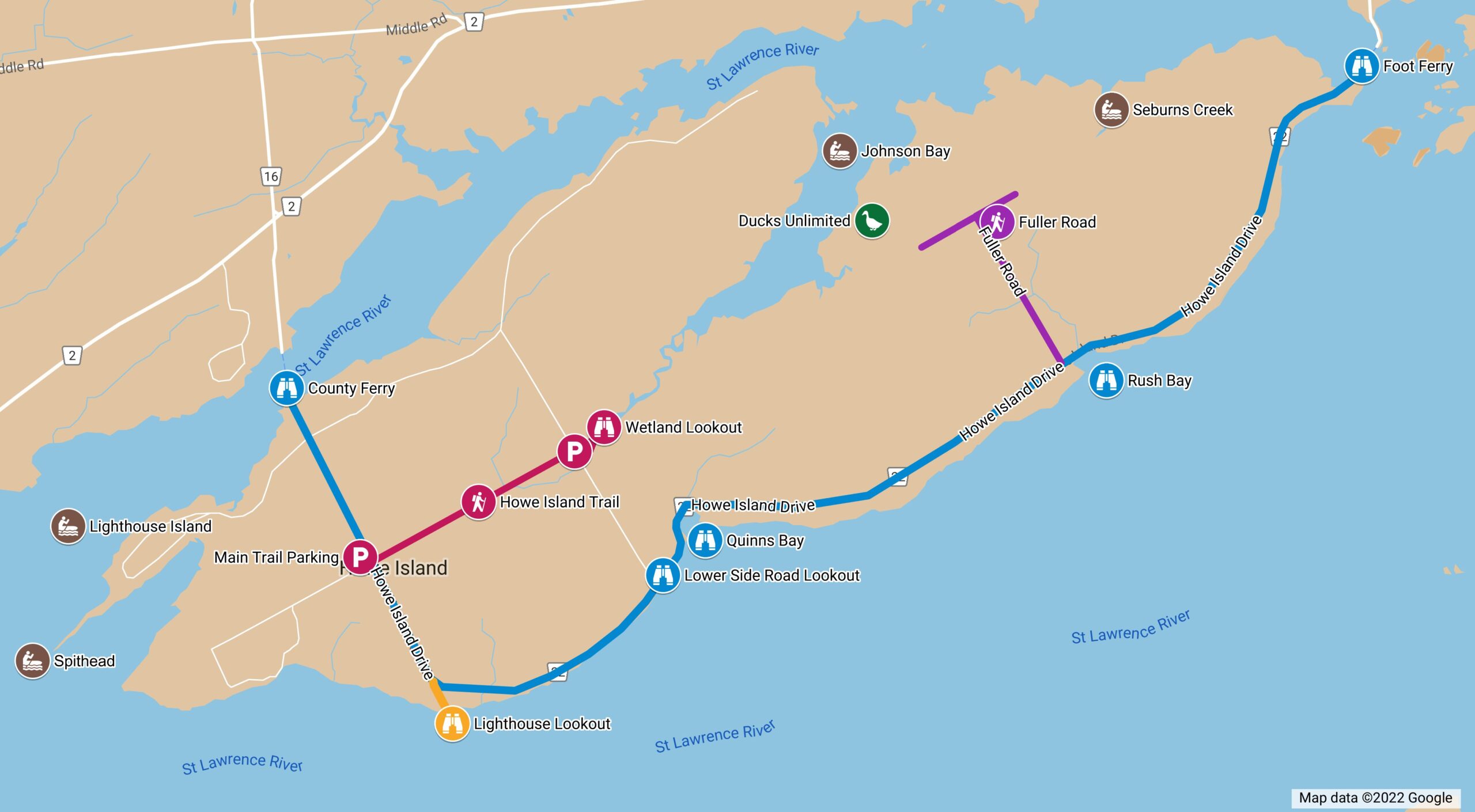
Access
Howe Island is accessible via a 15 car ferry (County Ferry) on the western end of the island and a three car ferry (Foot Ferry) on the eastern end of the island. The ferry fee for either ferry is $8 per car for a round trip paid in cash or via the Honk app. One fee works for both ferries, so you can arrive on the island on one ferry and leave on the other for no additional cost. There is ample parking at the County Ferry, so carpooling or hopping on a bicycle ($2 fee) are both options for saving some money. Howe Island includes various habitats including farmland (both pasture and crop), forests, scrub land and residential properties.
County Ferry
Although not a great spot (usually… a Razorbill spent some time there in 2021), you often have time to take a quick look while waiting for the ferry and with parking on both the mainland and the island, you can pause on either side for a longer look. Assuming you start on the County Ferry end, the rest of this guide should lead you quite nicely to the other end of the island.
Road Birding
Much of the island can be birded by car. There are several residential side roads with open fields and views of the water especially on the west end of the island. Spithead Road includes various habitats including a marsh area and an open field that is frequented by Bobolinks and Meadowlarks in season. North Shore Road has a few spots that look into Bateau Channel between Howe Island and the mainland. The entire stretch of Howe Island Drive is good for spotting raptors of all sorts flying or perching on the utility lines or the trees in and around the open fields. In winter, one might encounter flocks of Snow Buntings, redpolls or other flocking birds, so look ahead and in the bushes along the sides of the road. Although Howe Island is not busy traffic-wise, one should always be cognizant of and yield to other vehicles when birding. Use of four-way flashers and safety devices such as orange pylons is always a good idea. When parking, ensure you are not blocking the flow of traffic by pulling as far off the road as you can.
Howe Island Trail
The Howe Island Trail follows a road allowance and is maintained as a pedestrian trail. It is a mostly level gravel trail that is approximately 2.5 km one way (5 km round trip) with a small loop at the end. At the easternmost point, there is a wetland view which is obscured in the summer and fall with cattails, but can provide some interesting bird species when the view (and water) is open in the late winter and spring. The Howe Island Trail is used by locals and visitors for recreational walks, including dog walking and observing nature. In general, it is a treed corridor between farm fields. Some sections, most notably the eastern end, run through forested areas. As of the writing of this guide, 127 species of bird have been recorded using the Howe Island Trail EBird hotspot (L9268341). The main parking lot is less than two kilometres from the County Ferry on the west side of the road, and the trail starts on the east side of the road. A smaller parking lot is located on Lower Side Road. The only amenities on the trail are a couple of benches. A good time to visit the Howe Island Trail is in May during the spring warbler migration.
Lighthouse
At the end of Lighthouse lane is a small public park — with no amenities — that offers a wide view of the channel between Howe and Wolfe Islands. This can be a productive location at certain times of the year especially when much of the river is frozen and waterfowl congregate (which also means the Bald Eagles congregate) in open areas. You will likely want to bring a scope for this location. The lane itself is bushy on either side and is often full of birds.
Lower Side Road Lookout
Another open view of the river between Howe and Wolfe Islands is at the junction of Howe Island Drive and Lower Side Road. This spot is surrounded by private property, so you will need to stay on the roadside. From this vantage point, it is possible to see waterfowl especially during freeze-up in the autumn and thaw in the spring.
Quinns Bay
Continuing down Howe Island Drive a short distance, the road will wrap around Quinns Bay. There is a small area where a car can completely pull off the road on the north side of the road; otherwise, use caution where you park in this area as there can be traffic from both directions and poor visibility due to the curve. Several openings around the bay afford good views of the entire bay in which many waterfowl congregate during migration periods. Shorebirds, herons, and many other birds have been found near Quinns Bay.
Fuller Road
Heading down Howe Island Drive a few more kilometres will get you to Fuller Road. This is a gravel road that passes through open and forested areas. There is a T-junction at the end with about a one kilometre stretch of road in either direction. You will know you are at the end of the public road in both cases when you hit a gate. The Ducks Unlimited property mentioned earlier is beyond the west gate. Beyond the east gate is private property.
Although, not a public eBird hotspot, 114 bird species have been recorded on this road. A good strategy for Fuller Road is to find a spot to park — leaving room for infrequent traffic to get by — and walk the entire road either from the T-junction or from Howe Island Drive. It might also be worth taking a peek in Rush Bay as there are some rocks that birds frequent, and during migration, there are often plenty of birds to see on the water. You will likely not want to stop or park at Rush Bay due to the guardrails making it difficult to pull over. Combined with a blind curve and an 80 km speed limit, it is best to park on Fuller Road or in a visible spot further up Howe Island Drive and walk down.
Foot Ferry
At the end of Howe Island Drive, you will arrive at the Foot Ferry. This location allows for a wide view of the channel between Howe Island and the mainland and a distant view of the Admiralty Group of islands. In lower water, exposed rocks, especially on the mainland side of the foot ferry, are frequented by gulls, terns, geese, ducks, herons, and swans, allowing close views of species that are often hard to pin down.
For the Kayakers
As much of Howe Island is private land, it is difficult to get to much of the shoreline. In a kayak, however, you can view the entire shoreline including a couple of provincially significant wetlands: Johnson Bay and Seburns Creek. The former includes wetland habitat modified by Ducks Unlimited. On the west end of the island is the “Spithead” which is inaccessible from land but an easy paddle (in light winds) from the County Ferry. You can kayak from boat launches at either ferry (island side) with associated parking areas, Grass Creek Park (on the mainland) or any other public location that you find suitable.